FKDT (Fastest Known Duffel Time) of the Torres Del Paine 'O Circuit'
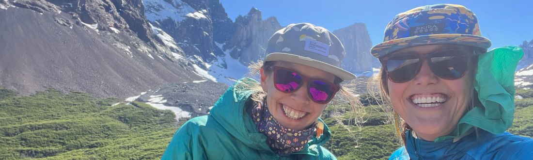
Zoë and Abby go on a field trip! To Patagonia! Rewind to late August when we booked tickets for a December trip on a whim. Fast forward to October when we realized we should add framework to this upcoming excursion of ours? Book an Airbnb so we have a place to stay when we arrive? Do we need a permit? Figure out transportation? Ya sure why not. People seem to think it’s the type of trip that needs a bit of planning, so we might as well listen to the veterans. We quickly realized it might not be a fly by the seat of our pants situation. Yes, refugio and camping reservations fill quickly, and yes we might need to book meals in advance. And no, there is not a lot of helpful info on how to go about all of it. But we did know one thing without even having to discuss it…you know those Free Range duffels?? The nifty ones that turn into backpacks? Yeah well we were taking them trekking. And enter what we are calling (please let us know if we are taking anyone’s title) the Fastest Known Duffel Time* of the O Circuit, Torres del Paine National Park, 89.1 miles/143.4 kilometers, 47 hours 13 minutes over eight days.
*Urban dictionary: Fastest Known Time. The fastest time anyone has completed a given task, i.e. running a trail, climbing a mountain, etc.
Watch this 50 second video for a feel of what's to come! And then keep scrolling for planning information and tips, packing list, and day by day reports based our experience.
PREPPING & PLANNING:
In general, there’s not a lot of information out there on how to DIY the Torres del Paine O Circuit. To have someone else plan and secure the travel, accommodations, route, and meals, head over to Las Torres or Vertice. If you’re a DIYer like ourselves take a look at how we planned our trip. Worked well for us!

In our opinion, starting and finishing the trip at Paine Grande worked out really well. Starting and finishing at Central is an alternate option. Our route was as follows:
- Day 1: arrive via the first (~10.30am) Paine Grande ferry, this gives the full day to explore the Británico overlook
- Night 1: stay at Cuernos (Frances would have been preferred, only because it would have shortened our first day)
- Day 2: Cuernos to Chileno
- Night 2: stay at Chileno
- Day 3: get up early for the sunrise (assume 2 hours to the base of the Towers from Chileno) and then pack up gear and head down to Central
- Night 3: stay at Central
- Day 4: hike Central to Serón
- Night 4: stay at Serón
- Day 5: hike Serón to Dickson
- Night 5: stay at Dickson
- Day 6: hike Dickson to Perros
- Night 6: stay at Perros
- Day 7: hike Perros to Grey
- Night 7: stay at Grey
- Day 8: Finish the O circuit and take the first or second ferry out of Paine Grande, back to Pudeto
Frances, Cuernos, Chileno, Central and Seron must be booked via Los Torres. Below is a general idea of how we went about booking the date sequence:

The availability of booking looks like the following:


Dickson, Perros, Grey & Paine Grande must be booked via Vertice Travel.

This was difficult to do only because Paine Grande and Grey are part of the more popular W Circuit. We would find availability at Dickson and Perros, but not at Grey, and we couldn’t book just two of the three. I checked back several times, but finally emailed Vertice to see if they had any extra campsites that weren’t listed and we were finally able to book all of the consecutive accommodations.
Check out reservations below to see all of the accommodations and full board options:


If starting and ending at Paine Grande, book Paine Grande as a last evening accommodation if planning on a leisurely morning at Grey before walking to Paine Grande, or if booking a bus/travel out from Pudeto back to Puerto Natales isn’t an option that day. We originally booked a last night at Paine Grande (night 8), but found out the hike was only ~3 hours at a clipped pace, so we changed our bus ticket, got up before sunrise and scooted out to catch the first ferry from Paine Grande to Pudeto. This resulted in us not needing the 8th night at Paine Grande.
We booked whatever was available: campsites, premium campsites or refugios. It is possible to rent a tent, mat or sleeping bag at each location, however, if they are unavailable to rent, be prepared to carry gear the entire trip! Also, this is the time to book your meals along with accommodations. Meals on the O Circuit are expensive, full board (dinner, breakfast, and to-go lunch) is approximately $80-100 USD a person, so plan accordingly. We took our own backpacking meals, but had fun ordering a la carte sandwiches, beers, pisco and/or calafate sours when we needed a treat! And in retrospect, $100 is actually quite reasonable when you consider how supplies are delivered (horses! boats!), and the locations where meals are prepared (in the middle of the mountains!).
Our packing list:
- Lululemon leggings/Fjällräven hiking pants (2)
- Vuori joggers and/or Patagonia insulated puffy pant (1)
- Patagonia trail shorts or Oiselle trail shorts (1)
- Patagonia short sleeve shirt, merino wool & capilene (2)
- Patagonia capilene long sleeve, UPF rating is ideal (2) *Zoë used a light button up shirt (gem of a thrift store find) in lieu of a capilene long sleeve
- North Face insulated vest
- Patagonia Houdini jacket
- Rain jacket - Patagonia or Outdoor Research
- Rain pants (helpful for wind too) - Mountain Hardwear or Patagonia
- Lightweight, packable insulated jacket - Outdoor Research or Arc’teryx
- Merrell hiking socks (4) or Stance running socks (4)
- Darn Tough tall wool socks for camp/sleeping (1)
- Beanie
- Skida hat
- Lightweight Gloves or Hella Sweet Mittens
- Blackstrap neck gaiter or Buff
- Black Diamond headlamp
- Oiselle or Lululemon sports bra (2)
- Patagonia undies (6)
- Homemade bandana (yes please!)
- First aid kit
- Toiletries
- 3L HydraPak water bottle w/purifier lid or quick access 1L HydraPak
- Dr Bronner’s - for clothes washing & as soap
- Vintar Plug in adapter (Chile specific adapter)
- Phone cords
- Anker Battery pack/Goal Zero battery pack
- Chaco sandals or Rainbow flip flops
- Chaco hiking boots/Salomon trail running shoes
- Bathing suit
- Black Diamond trekking poles
- Sunscreen
- Passport, credit cards, Global Entry card, etc.
- Backpacking Stove (Snow Peak)
- Pot or we used a GSI teapot
- Bowl or cup for meals
- Utensils
- Sleeping bag
- Thermarest sleeping pad
- Roll of duct tape
- EXPED tent
- Free Range Duffel
- Free Range Phanny
- Hand warmers
- Deck of cards
- Yahtzee dice
Food:
- Misery Bay Coffee - single satchels
- Tea packets
- Oatmeal
- Picky Bars & GoMacro Bars
- LMNT Electrolytes
- Backpacker’s Pantry & Alpine Aire backpacking dinner meals (7 minimally)
We booked our flights to Punta Arenas, Chile (PUQ) based on the price. It was cheaper to fly into Punta Arenas than directly to Puerto Natales, Chile. For convenience, fly into Puerto Natales. We purchased bus tickets via Bus Sur for a 3h 15m bus to Puerto Natales, making sure we booked tickets from the Puerto Natales airport and not 20 minutes away in the Punta Arenas city center. The bus pulls up right in front of the airport (it might be running a little late, but it'll show up). We didn’t check luggage and had gone through customs in Santiago, so we walked out and were able to jump on the bus. For WiFi at the airport, ask the information desk for the free password.
Pro tips:
- While going through immigration into Chile, they hand out a PDI receipt. This is VERY important to keep, as it must shown at each refugio check in along with a passport, and again when leaving the country!
- There was no WiFi on the bus, but comfortable seats! We read and snoozed as we headed toward Puerto Natales.
- Download the Google Translate app and save Spanish offline.
- Download Google Maps for the areas (Punta Arenas, Puerto Natales and Torres del Paine) to easily navigate without service. We created maps with bus station locations, our Airbnb, supermarkets, coffee shops and places to eat or see. We found it easy to make our way around without paying for international phone service.
- Download all reservations on a phone for easy access. We printed all our reservations as well, but found this unnecessary as long as they were on our phone. This goes for all refugios, campsites, park entry permits and bus reservations.
We needed to secure a few necessary items before heading out for our hike. Since we only had carry on luggage (no checked bags), upon arrival we acquired a knife, propane for our camp stove, lots of snacks, chocolate and wine. We booked a really great Airbnb at Pire Mapu Cotttages in Puerto Natales. It came with a brown bag breakfast which was clutch when we were catching the 6:45am bus! There are several rooms on the Pire Mapu property, that link will show one room and it's worth digging a little deeper to see if others are available if that particular one is booked. Our Airbnb host was kind enough to share another backpacker’s lightly used propane, which somehow got us through the whole trip, but we could have easily picked some up at various outdoor stores and at snack shops along the trail. We brought our own backpacking meals from the States, as well as oatmeal packets and snack bars. We immediately fell in love with the Chilean red wine, Carménère, and went with a screw top for ease of carrying it with us. In retrospect, we should have brought an extra Hydrapak specifically for carrying our wine!
Puerto Natales is a delightful little town right on the water. On our first night we treated ourselves to a ceviche, fresh fish, pisco sour and Carménère dinner at Santolla, a cool little restaurant built in shipping containers near the water.
Other Puerto Natales recommendations: Last Hope Distillery, Mesita Grande, Holaste! Specialty Coffee, El Obrador Panaderia Artesanal
We woke up early for our bus from Puerto Natales Rodovario to Torres del Paine. We were glad we booked this bus in advance as it is very popular. There is an option to book to Laguna Amarga if starting at Central but we booked to Pudeto since we were taking the catamarán/ferry to Paine Grande.
Our trip by the dollars:
- CONAF Park Entrance: $49 each
Important Things to Know!
- We were glad we booked our CONAF National Park access for Torres del Paine in advance as we had to show proof of purchase when we stopped at the park entrance. We could not purchase a ticket there, so plan in advance! We boarded the same bus to take us on to Pudeto, but this was where others transferred to their respective locations.
- The catamarán/ferry from Pudeto is first come, first serve and CASH only! Be prepared with $25,000 Chilean pesos (CLP) or $30 US dollars per person, one way. Budget accordingly for roundtrip as there is nowhere to get cash onsite!!
- We watched several people be turned away from buses when they thought they could hop on an earlier bus than they booked. Plan accordingly to catch the best timed ferry for a bus departure! Ferry times change depending on the time of year.
THE LOOP:
DAY 1: Paine Grande to Quernos: 27.03 kilometers/16.8 miles
Practically blown off the ferry and along the trail by the wickedly windy conditions. Ahhh, so that’s the wind we had been warned about! And it’s no joke. Noted! The first section of trail winds its way along the lake until the Italiano Ranger station at the base of Valle de Frances. Highly recommend the Valle de Frances side trip! We left our duffels among the fifty or so other packs at the ranger station and made a beeline for the highest viewpoint wearing just our phanny packs. Approximately 5.5km and 1.5 hours later we had passed the first mirador (viewpoint) and reached the Mirador Británico. By a miraculous stroke of luck we had the whole thing to ourselves since we arrived late in the day.

Lucky for us, sunset wasn’t until ~9:45pm! We backtracked our steps to Italiano, retrieved our bags (lonely duffels at that point since we were the last ones down!) and carried on to Cuernos. The most magical part of the next few kilometers was emerging onto a long pebble beach (part of the trail), still bathed in warm sunshine at 9pm in the evening. We immediately stripped down to our birthday suits for a dip. The remaining 1km was longer than both of us would have liked, but we made it ;) Cuernos was one of our refugio bed nights and we ended up in an eight bed bunk room with two other girls. After being scolded for cooking on the main deck, we relocated to the Cook Room a few steps uphill.
Pro tips:
- The camper's bathroom was actually much nicer than the Refugio bathroom.
- This was our first PDI need!
- Water...it's drinkable from the tap everywhere along the loop! Yippee!
DAY 2: Cuernos to Chileno: 13.55 kilometers/8.42 miles
Beautiful walk that finished with heading up a valley (along with pack horses carrying kegs and other important supplies) to Chileno. In order to witness the towers at dawn, Chileno is for sure the spot to spend the night! We reserved a campsite which ended up being on a platform on stilts on a steep hillside. Chileno is perched beside a river and seemed to have quesadillas and hamburgers (both 14,000 CLP) as their a la carte food items. Really excellent sunshiny deck for bevvies and card games if we do say so ourselves!


Pro tips:
- Beverage specials at Chileno if you buy two at a time!
- The river is lovely, cold, and prime for a refreshing dip.
DAY 3: Chileno to Central: 20.38 kilometers/12.66 miles
Bright and early alarm at 3:45am and off to sunrise at the towers we went!! Our first few days of weather were incredibly good and this one in particular couldn’t have dawned sunnier or with a bluer sky. We left our tent on its platform and trekked up with phanny packs and lots of layers in preparation for watching the sunrise. We arrived to an amusing IG vs reality situation due to the sheer numbers (100+) of early morning spectators also appreciating the slow roll of the sunrise on the towers. After a very chilly hour sitting on a rock we meandered back down the hill, packed up, and carried on our way. This was the busiest trail day of our circuit due to the close proximity of a road, ie buses, depositing a conga line of day hikers heading up the trail to the towers. We ended up at Central, a delightful campground amongst trees and open grassy patches. The showers were amazing; also our first of the trip so they had that going for them. The calafate sour at the bar and restaurant across the bridge was also amazing and our favorite of the trip. Snacks available in the welcome center across the bridge. And a food truck! Both of us agreed Central was one of our favorite camp spots!
Pro tips:
- WiFi - It's available at most refugios, for a cost. Usually around 8,000 CLP per hour. We never used it so we can't speak to how fast, slow, or reliable it was!
- The trail between Chileno and Central is in full sun and it's worth liberal use of sunscreen on a sunshiny or even cloudy day.

DAY 4: Central to Serón: 17.80 kilometers/11.06 miles
And off we went on our first day of the O! Up until this day we had been mixing and mingling with W trekkers. From this day on there were fewer people and everyone walked the same direction (counter clockwise). Another warm day and we even opted for shorts! This day had us thinking we were on some sort of Saharan safari due to the landscape and vegetation. A highlight was a compliment from a group of girls studying abroad from the US: “We were discussing how dripped out you two were.” Yes, why thank you!! ;)

Pro tip:
- There is a really spectacular field of dandelions with a view of some mountains that is prime for mid hike reading and/or a catnap. We came around a left hand curve right before a creek crossing to find the field stretched out in front of us and calling our names. We were there in early December, we can't guarantee dandelions in bloom at all times…
DAY 5: Serón to Dickson: 18.93 kilometers/11.76 miles
One of our favorite days of walking! Up and over a little pass and then the trail contoured a hillside with a long lake at the bottom of the valley. Two thirds of the way to Dickson we came across a check in at a ranger station. If our interpretation of the Spanish instructions was correct, hikers have to reach this ranger station by a certain time if they plan to skip Dickson and carry on to Perros for the night. At Dickson's restaurant we opted for the a la cart Guanaco sandwich and pisco sours at the restaurant, and although we fully realize almost anything tastes amazing after a long day of exercise, both items HIT. THE. SPOT.


Pro tip:
- Keep your eyes peeled for pumas! We didn't see hide nor hair of the elusive creatures, but it was around Dickson that we were alerted to their potential presence and kept our eyes peeled. We imagined they were constantly spying on us even though we didn't see them!
DAY 6: Dickson to Perros: 14.40 kilometers/8.95 miles
Sneaky long day! There seem to be varying and conflicting reports of distances between refugios, especially when it comes to the old wooden signs along the trail. One of our maps said this day was 9km, but Strava (on our phones) calculated closer to 14km. The trail spent a lot of time in thick woods along a river which made for prime mosquito and bug territory. If possible, it’s worth holding out until the lake with a view of the glacier for a lunch stop. It’s a hop skip and a jump from the lake to Perros, but boasted the least number of bugs and the best view. Perros was the one refugio without hot water (although they still had showers available). Also one of two locations (the other being Serón that didn’t offer a la carte food items in addition to the meal plan.

Day 7: Perros to Grey: 17.56 kilometers/10.91 miles
Weeoooo this was the long day!! We were all kicked out of camp bright and early at 7am in order to give everyone ample time to make it to Grey at a reasonable hour. It was up, up and away from the moment we set foot on the trail until we reached the John Garner Pass at 1200 meters/3900 feet. We had an impromptu dance party on the pass with a view of the Grey Glacier on the other side and then down the other side we slipped and slid. There were a few snow crossings on the way up and the way down. Nothing too sketchy or scary although we crossed when the snow was in prime condition, not too firm or too soft. No crampons or spikes necessary, although some people might feel more comfortable with them. There was a spicy section on the way down with a bobsled-esque track through the trees and from then on the trail wound its way down towards and along the Grey Glacier.
The Grey Glacier…WOW. It stretches on and on as far as the eye can see! There was one checkpoint located at the Passo Ranger Station three hours from Refugio Grey. We’re not entirely sure what the ranger station checkpoints are for, but we assume to keep track of everyone in the park and ensure hikers made it safely over the pass. Refugio Grey felt like returning to civilization since many visitors are dropped at Paine Grande and hike the 13km (~3hrs) to the glacier viewpoint either for one night or even just a day trip. Restaurant! Bar! Espresso vending machine! Camp store packed with more items than usual! Lots of people and new faces! It was delightful meeting up in the restaurant (after a luxuriously hot shower) with our O Circuit cohort to celebrate a long, fun day in the mountains.

Pro tip:
- If there was one day for trekking poles, this was probably the day!
DAY 8: Grey to Paine Grande: 11.45 kilometers/7.11 miles
We had originally planned to keep this day leisurely, walk to Paine Grande, and stay the night there before hopping on the catamarán/ferry the next morning. However, we realized we could leave Grey at ~5.30am and catch the first catamarán/ferry from Paine Grande at 9.30am. Our reasoning for this was to give us a bonus day (hello penguins of Tierra del Fuego!) before heading back to Oregon. The trail is flat for a while before stair stepping its way to the top of a ridge and dropping down the other side to Paine Grande. This was our one day of iffy weather that included wind and spitting rain and lucky for us, it fell on the one day that we had a delightful Airbnb in Puerto Natales at the far end of it!

Pro Tips:
- Leave a few minutes for treats from the Patagonia Blends espresso machine and/or treat at the Paine Grande restaurant before getting on the ferry. Yummm.
- Rain pants double well as boat pants to protect from rogue water spray that often reaches the top deck of the catamarán/ferry.
A note about our pack, ie. duffel choice:
We went the duffel route because we wanted to see if we could fit all we needed (we did!) and if they would be comfortable (they were!) over an eight day trek. Would we do it again? Heck yes! Is it right for everyone? Who knows?! We think so, but it's always worth testing out your equipment before embarking on an adventure of any magnitude, big or small. For us, the duffels checked all the boxes...functionality, appropriate size, comfortable, and just as important (if not more) as any of the above items, they were conversation starters that forged relationships while also adding a splash of color, beauty and spunk to the world!

Cheers and thanks for tuning in to the adventures of Abby and Zoë!